


Hazardous Weather Conditions
Current conditions at
Myrtle Beach International Airport (KMYR)
Lat: 33.68°NLon: 78.93°WElev: 25ft.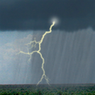
Thunderstorm in Vicinity
27°C
80°F
| Humidity | 82% |
| Wind Speed | S 28 km/h |
| Barometer | 1005.0 mb (29.68 in) |
| Dewpoint | 23°C (74°F) |
| Visibility | 16 km |
| Heat Index | 29°C (85°F) |
| Last update | 15 May 2:56 pm EDT |
Extended Forecast for
Myrtle Beach SC
Severe T-storm Watch until May 15, 08:00pm
NOW until 8:00pm Wed

Severe T-storm Watch
This Afternoon

High: 27 °C
Severe
ThunderstormsTonight
Low: 18 °C
Severe
Thunderstorms
then Partly
CloudyThursday
High: 26 °C
Mostly Sunny
then Slight
Chance
ShowersThursday Night

Low: 18 °C
Mostly Clear
Friday

High: 27 °C
Mostly Sunny
Friday Night
Low: 21 °C
Slight Chance
T-storms then
Chance
ShowersSaturday

High: 27 °C
Showers
Saturday Night

Low: 19 °C
Showers
Detailed Forecast
This Afternoon
A chance of showers and thunderstorms. Some of the storms could be severe. Partly sunny, with a high near 27. Southwest wind around 18 km/h, with gusts as high as 29 km/h. Chance of precipitation is 30%. New rainfall amounts between 1 and 2.5 mm, except higher amounts possible in thunderstorms.
Tonight
Showers and thunderstorms likely, mainly before 9pm. Some of the storms could be severe. Partly cloudy, with a low around 18. Southwest wind 8 to 11 km/h. Chance of precipitation is 60%. New precipitation amounts between 1 and 2.5 mm, except higher amounts possible in thunderstorms.
Thursday
A slight chance of showers after 2pm. Mostly sunny, with a high near 26. Northwest wind 8 to 10 km/h. Chance of precipitation is 20%.
Thursday Night
Mostly clear, with a low around 18. Calm wind.
Friday
Mostly sunny, with a high near 27. Light south wind increasing to 9 to 14 km/h in the morning.
Friday Night
A chance of showers and thunderstorms, mainly after 2am. Mostly cloudy, with a low around 21. Chance of precipitation is 50%. New rainfall amounts between 1 and 2.5 mm, except higher amounts possible in thunderstorms.
Saturday
Showers likely, then showers and possibly a thunderstorm after 2pm. High near 27. Chance of precipitation is 80%.
Saturday Night
Showers and possibly a thunderstorm before 8pm, then showers likely. Low around 19. Chance of precipitation is 80%.
Sunday
A chance of showers. Mostly sunny, with a high near 27. Chance of precipitation is 40%.
Sunday Night
Partly cloudy, with a low around 17.
Monday
Mostly sunny, with a high near 26.
Monday Night
Mostly clear, with a low around 17.
Tuesday
Mostly sunny, with a high near 27.
Tuesday Night
Mostly clear, with a low around 19.
Wednesday
Mostly sunny, with a high near 28.
Additional Forecasts and Information
ABOUT THIS FORECAST
Point Forecast:
Myrtle Beach SC
33.69°N 78.9°W (Elev. 23 m)
33.69°N 78.9°W (Elev. 23 m)
3:16 pm EDT May 15, 2024
3pm EDT May 15, 2024-6pm EDT May 22, 2024
Additional Resources
Radar & Satellite Image


Hourly Weather Forecast


