


News Headlines
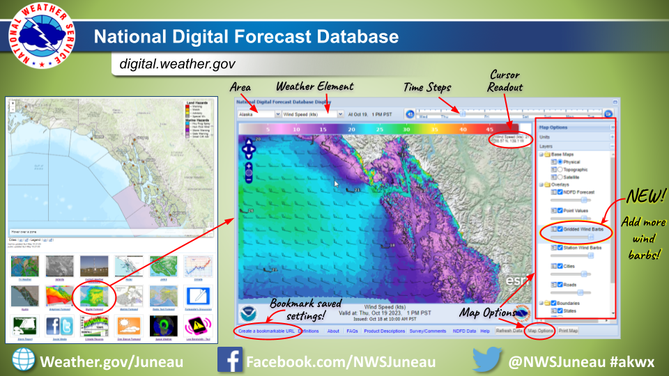
- Forecast graphics improvement: A new layer with additional wind barbs can now be added to forecast maps on digital.weather.gov. Please see the linked image to see how to navigate and add the new layer.
- NWS forecast pages underwent updates, effective April 30th. To learn more about the specific modifications and known issues, please click here.
- The new National Water Prediction Service (NWPS) is live and operational. This is replacing the Advanced Hydrologic Prediction Service (AHPS). AHPS will continue to function until May 27. Now is the time to update your links/bookmarks.

Current conditions at
Elfin Cove - Elfin Cove Seaplane Base (PAEL)
Lat: 58.19°NLon: 136.35°WElev: 26ft.
Mostly Cloudy
54°F
12°C
| Humidity | 54% |
| Wind Speed | Calm |
| Barometer | 29.50 in |
| Dewpoint | 37°F (3°C) |
| Visibility | NA |
| Last update | 4 May 6:52 pm AKDT |
Extended Forecast for
23 Miles ESE Cape Fairweather AK
Tonight

Low: 18 °F
Snow
Sunday

High: 24 °F
Snow
Sunday Night
Low: 13 °F
Snow then
Rain/SnowMonday

High: 22 °F
Snow Likely
Monday Night

Low: 11 °F
Heavy Snow
Tuesday

High: 16 °F
Heavy Snow
Tuesday Night
Low: 10 °F
Snow
Wednesday

High: 18 °F
Snow
Wednesday Night

Low: 14 °F
Heavy Snow
Detailed Forecast
Tonight
Snow, mainly after 10pm. Low around 18. East wind 15 to 20 mph. Chance of precipitation is 90%. Total nighttime snow accumulation of 1 to 2 inches possible.
Sunday
Snow. High near 24. East wind around 15 mph, with gusts as high as 30 mph. Chance of precipitation is 100%. New snow accumulation of 1 to 3 inches possible.
Sunday Night
Snow before 1am, then periods of rain between 1am and 4am, then periods of rain, possibly mixed with snow after 4am. Low around 13. East wind around 15 mph. Chance of precipitation is 80%. New snow accumulation of less than one inch possible.
Monday
Snow likely, mainly between 7am and 4pm. Mostly cloudy, with a high near 22. South wind around 15 mph. Chance of precipitation is 70%.
Monday Night
Snow, mainly after 10pm. The snow could be heavy at times. Low around 11. South wind around 10 mph. Chance of precipitation is 80%.
Tuesday
Snow. The snow could be heavy at times. High near 16. Chance of precipitation is 80%.
Tuesday Night
Snow. Low around 10. Chance of precipitation is 90%.
Wednesday
Snow. Cloudy, with a high near 18.
Wednesday Night
Snow. The snow could be heavy at times. Mostly cloudy, with a low around 14.
Thursday
Snow. Cloudy, with a high near 19.
Thursday Night
Snow likely. Cloudy, with a low around 13.
Friday
Snow likely. Cloudy, with a high near 18.
Friday Night
Snow likely. Mostly cloudy, with a low around 13.
Saturday
A chance of snow. Mostly cloudy, with a high near 19.
ABOUT THIS FORECAST
Point Forecast:
23 Miles ESE Cape Fairweather AK
58.75°N 137.33°W (Elev. 8199 ft)
58.75°N 137.33°W (Elev. 8199 ft)
3:27 pm AKDT May 4, 2024
9pm AKDT May 4, 2024-6pm AKDT May 11, 2024
Additional Resources
Radar & Satellite Image


Hourly Weather Forecast


