


News Headlines
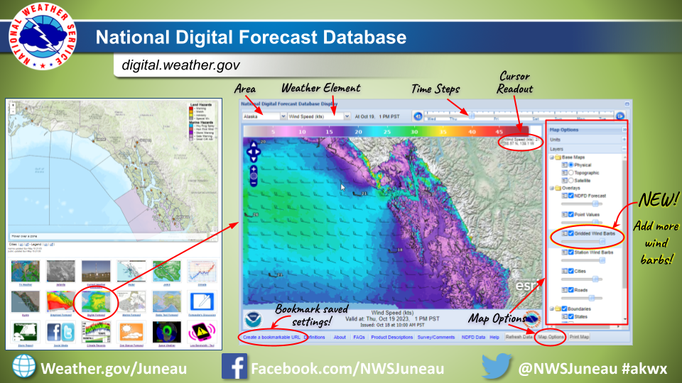
- Forecast graphics improvement: A new layer with additional wind barbs can now be added to forecast maps on digital.weather.gov. Please see the linked image to see how to navigate and add the new layer.
- NWS forecast pages underwent updates, effective April 30th. To learn more about the specific modifications and known issues, please click here.
- The new National Water Prediction Service (NWPS) is live and operational. This is replacing the Advanced Hydrologic Prediction Service (AHPS). AHPS will continue to function until May 27. Now is the time to update your links/bookmarks.

For More Weather Information:
Tonight

Low: 45 °F
SE 10kt
1-2ftSunday

High: 52 °F
SE 10kt
2ftSunday Night
Low: 41 °F
Light Wind
1ftMonday
High: 51 °F
Light Wind
1ftMonday Night
Low: 38 °F
Light Wind
1ftTuesday
High: 50 °F
Light Wind
1ftTuesday Night
Low: 39 °F
⇑S 20kt
1-2ftWednesday
High: 52 °F
ESE 25kt
3ftWednesday Night
Low: 41 °F
WSW 20kt
2ft
High and low forecast temperature values represent air temperature.
Water temperature forecast is experimental.
Associated Zone Forecast which includes this point
Last Update: 3:27 pm AKDT May 4, 2024
Forecast Valid: 8pm AKDT May 4, 2024-6pm AKDT May 11, 2024
View Nearby Observations
Detailed Forecast
Synopsis: A front over the northeast gulf coast will spread south and east
across the rest of Southeast Alaska by Sunday morning. Active
weather will persist through mid next week as a series of fronts
move across the region.
Tonight
SE wind 5 to 10 kt. Periods of rain, mainly after 4am. Seas 1 to 2 ft.
Sunday
SE wind around 10 kt. Periods of rain. Seas around 2 ft.
Sunday Night
Variable winds 5 kt or less. Rain. Seas around 1 ft.
Monday
Variable winds 5 kt or less. Periods of rain. Seas around 1 ft.
Monday Night
Variable winds 5 kt or less. Rain likely, mainly before 10pm. Seas around 1 ft.
Tuesday
Variable winds 5 kt or less. Rain likely, mainly before 1pm. Seas around 1 ft.
Tuesday Night
WSW wind 5 to 10 kt becoming S 15 to 20 kt after midnight. Rain, mainly after 10pm. Seas 1 to 2 ft.
Wednesday
ESE wind 20 to 25 kt, with gusts as high as 35 kt. Rain. Seas around 3 ft.
Wednesday Night
WSW wind 10 to 20 kt. Rain likely. Seas around 2 ft.
*Notices:
- This forecast is for a single location. For safety concerns, mariners should be aware of the weather over a larger area. Forecast information for a larger area can be found within the zone forecast and the NDFD graphics.
- The forecast conditions at a particular point may not exceed the criteria of a Small Craft Advisory, Gale, Storm etc. These watches/warnings/advisories are issued for the entire zone in which the point resides and mariners should act accordingly.
ABOUT THIS FORECAST
| Point Forecast: | 56.62°N 132.5°W |
| Last Update: | 3:27 pm AKDT May 4, 2024 |
| Forecast Valid: | 8pm AKDT May 4, 2024-6pm AKDT May 11, 2024 |
| Forecast Discussion | |
|
|
RADAR & SATELLITE IMAGES


