


News Headlines
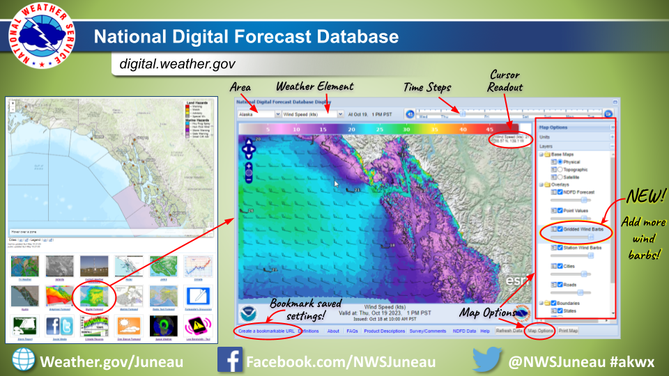
- Forecast graphics improvement: A new layer with additional wind barbs can now be added to forecast maps on digital.weather.gov. Please see the linked image to see how to navigate and add the new layer.
- NWS forecast pages underwent updates, effective April 30th. To learn more about the specific modifications and known issues, please click here.
- The new National Water Prediction Service (NWPS) is live and operational. This is replacing the Advanced Hydrologic Prediction Service (AHPS). AHPS will continue to function until May 27. Now is the time to update your links/bookmarks.

Current conditions at
Juneau, Juneau International Airport (PAJN)
Lat: 58.35°NLon: 134.58°WElev: 20ft.
Light Rain Fog/Mist
45°F
7°C
| Humidity | 90% |
| Wind Speed | W 7 mph |
| Barometer | 29.43 in (996.6 mb) |
| Dewpoint | 42°F (6°C) |
| Visibility | 5.00 mi |
| Wind Chill | 41°F (5°C) |
| Last update | 5 May 8:53 pm AKDT |
Extended Forecast for
3 Miles E Outer Point AK
Tonight

Low: 35 °F
Heavy Rain
Monday

High: 45 °F
Rain
Monday Night
Low: 31 °F
Rain then
Rain/SnowTuesday
High: 40 °F
Rain/Snow
then Rain
LikelyTuesday Night
Low: 31 °F
Rain then
Rain/SnowWednesday
High: 42 °F
Rain/Snow
then RainWednesday Night
Low: 33 °F
Rain Likely
then Chance
Rain/SnowThursday

High: 42 °F
Rain Likely
Thursday Night
Low: 33 °F
Rain/Snow
then Snow
Detailed Forecast
Tonight
Rain. The rain could be heavy at times. Low around 35. Southeast wind 10 to 15 mph. Chance of precipitation is 90%. New precipitation amounts between a quarter and half of an inch possible.
Monday
Periods of rain, mainly after 10am. High near 45. Southeast wind around 10 mph. Chance of precipitation is 80%. New precipitation amounts between a tenth and quarter of an inch possible.
Monday Night
Periods of rain before 1am, then periods of snow. Low around 31. Southeast wind around 10 mph. Chance of precipitation is 80%. New snow accumulation of less than a half inch possible.
Tuesday
Periods of snow before 10am, then rain likely. High near 40. Southeast wind 20 to 25 mph. Chance of precipitation is 80%.
Tuesday Night
Rain before 1am, then snow. Low around 31. East wind 20 to 30 mph, with gusts as high as 50 mph. Chance of precipitation is 90%.
Wednesday
Snow before 10am, then rain. High near 42. Chance of precipitation is 90%.
Wednesday Night
Rain likely before 1am, then a chance of rain and snow. Cloudy, with a low around 33. Chance of precipitation is 60%.
Thursday
Rain likely, mainly before 4pm. Cloudy, with a high near 42.
Thursday Night
A chance of rain before 10pm, then snow. Cloudy, with a low around 33.
Friday
Snow before 10am, then rain. Cloudy, with a high near 43.
Friday Night
A chance of rain. Mostly cloudy, with a low around 33.
Saturday
Mostly cloudy, with a high near 44.
Saturday Night
A chance of rain. Mostly cloudy, with a low around 34.
Sunday
A chance of rain. Mostly cloudy, with a high near 50.
ABOUT THIS FORECAST
Point Forecast:
3 Miles E Outer Point AK
58.28°N 134.62°W (Elev. 2572 ft)
58.28°N 134.62°W (Elev. 2572 ft)
3:35 pm AKDT May 5, 2024
9pm AKDT May 5, 2024-6pm AKDT May 12, 2024
Additional Resources
Radar & Satellite Image


Hourly Weather Forecast


