


Showers and thunderstorms tonight, lingering chances east Friday, then a mostly dry and very warm weekend
Showers and thunderstorms are expected overnight, with lows in the 50s. Some showers and storms may linger Friday around US-127. The weekend looks very warm with highs in the 80s, which is about 10 to 15 degrees above normal. Other than a small chance for showers and thunderstorms near I-94 on Saturday afternoon, the weekend should be dry overall for Southwest Lower Michigan. Read More >
Hazardous Weather Conditions

Current conditions at
Ludington, Mason County Airport (KLDM)
Lat: 43.97° N Lon: 86.4° W Elev: 646 ft.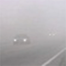
Fog
56°F
13°C
| Humidity | 96% |
| Wind Speed | Calm |
| Barometer | 29.77 in |
| Dewpoint | 55°F (13°C) |
| Visibility | 0.15 mi |
| Last update | 17 May 7:15 am EDT |
Detailed forecast for
Oceana County
Today
Mostly sunny. Patchy fog until midday. Highs in the mid 60s near lake michigan in the mid 70s inland. Light winds becoming northwest 5 to 10 mph in the afternoon.
Tonight
Mostly clear. Patchy fog overnight. Lows around 50. Light winds.
Saturday
Sunny. Highs in the lower 70s near lake michigan and around 80 inland. Light winds becoming southwest 5 to 10 mph in the afternoon.
Saturday Night
Mostly clear. Lows in the mid 50s. Light winds.
Sunday
Sunny. Highs in the lower 70s near lake michigan and around 80 inland. Light winds becoming northwest 5 to 10 mph in the afternoon.
Sunday Night
Partly cloudy. Lows in the upper 50s.
Monday
Mostly sunny until midday then becoming partly sunny. A chance of rain showers and a slight chance of thunderstorms. Highs in the mid to upper 70s. Chance of rain 40 percent.
Monday Night
Rain showers likely and a chance of thunderstorms. Lows in the upper 50s. Chance of rain 60 percent.
Tuesday
Rain showers likely and a chance of thunderstorms. Highs in the mid 70s. Chance of rain 70 percent.
Tuesday Night
Rain showers and a chance of thunderstorms. Lows in the mid 50s. Chance of rain 80 percent.
Wednesday
Partly sunny until midday then becoming mostly sunny. A 50 percent chance of showers and thunderstorms. Highs in the upper 60s.
Wednesday Night
Partly cloudy with a 30 percent chance of rain showers. Lows around 50.
Thursday
Mostly sunny with a 20 percent chance of rain showers. Highs in the mid 60s.
Additional Forecasts and Information
Additional Resources
Radar & Satellite Image


Hourly Weather Forecast


