


Hazardous Weather Conditions
Current conditions at
Ciudad Juarez International (MMCS)
Lat: 31.63°NLon: 106.43°WElev: 3842ft.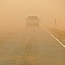
Blowing Dust
34°C
93°F
| Humidity | 15% |
| Wind Speed | S 31 G 50 km/h |
| Barometer | 29.87 in |
| Dewpoint | 4°C (39°F) |
| Visibility | 3.22 km |
| Heat Index | 32°C (89°F) |
| Last update | 7 Jun 8:12 pm CDT |
Extended Forecast for
Fabens TX
Heat Advisory June 7, 07:17pm until June 9, 06:00am
NOW until 6:00am Sun

Heat Advisory
Tonight

Low: 22 °C
Scattered
ShowersSaturday
High: 39 °C
Partly Sunny
then Slight
Chance
ShowersSaturday Night
Low: 23 °C
Slight Chance
Showers then
Partly CloudySunday

High: 38 °C
Hot
Sunday Night
Low: 20 °C
Slight Chance
Showers then
Mostly ClearMonday
High: 37 °C
Sunny then
Slight Chance
ShowersMonday Night

Low: 19 °C
Mostly Clear
Tuesday
High: 39 °C
Hot
Detailed Forecast
Tonight
Scattered showers and thunderstorms before midnight, then isolated showers between midnight and 1am. Mostly cloudy, with a low around 22. South southwest wind 10 to 14 km/h becoming east southeast after midnight. Chance of precipitation is 30%.
Saturday
A 20 percent chance of showers after 5pm. Mostly sunny and hot, with a high near 39. East southeast wind 10 to 15 km/h becoming west 18 to 23 km/h in the morning. Winds could gust as high as 34 km/h.
Saturday Night
A 20 percent chance of showers before midnight. Partly cloudy, with a low around 23. West southwest wind 11 to 21 km/h, with gusts as high as 32 km/h.
Sunday
Mostly sunny and hot, with a high near 38. West wind 14 to 19 km/h increasing to 21 to 26 km/h in the afternoon. Winds could gust as high as 39 km/h.
Sunday Night
A 10 percent chance of showers before midnight. Mostly clear, with a low around 20. West wind 18 to 23 km/h decreasing to 10 to 15 km/h after midnight. Winds could gust as high as 34 km/h.
Monday
A 10 percent chance of showers after noon. Sunny, with a high near 37. West wind 10 to 18 km/h, with gusts as high as 29 km/h.
Monday Night
Mostly clear, with a low around 19. West wind 8 to 16 km/h becoming east southeast after midnight.
Tuesday
Sunny and hot, with a high near 39. South southeast wind 8 to 11 km/h becoming west northwest in the afternoon.
Tuesday Night
Mostly clear, with a low around 22. West northwest wind around 10 km/h becoming east southeast after midnight.
Wednesday
Sunny and hot, with a high near 41.
Wednesday Night
Mostly clear, with a low around 22.
Thursday
Sunny and hot, with a high near 42.
Thursday Night
Mostly clear, with a low around 23.
Friday
Sunny and hot, with a high near 41.
Additional Forecasts and Information
ABOUT THIS FORECAST
Point Forecast:
Fabens TX
31.49°N 106.16°W (Elev. 3622 m)
31.49°N 106.16°W (Elev. 3622 m)
5:14 pm MDT Jun 7, 2024
7pm MDT Jun 7, 2024-6pm MDT Jun 14, 2024
Additional Resources
Radar & Satellite Image


Hourly Weather Forecast


