Showers and Thunderstorms for the East; Cooler Temperatures Return Sunday into Early Week

Showers and thunderstorms will accompany a cold front that will move across the eastern third of the country through Sunday. In the wake of this front, cooler temperatures will follow for most areas east of the Rockies. A wet pattern is expected to unfold across most of Florida this week with a persistent onshore flow and increase rip currents. For Hawaii, a return toward more rain the week ahead. Read More >

Current conditions at

Ciudad Juarez International (MMCS)

Lat: 31.63°NLon: 106.43°WElev: 3842ft.
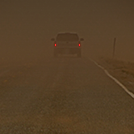
Mostly Cloudy

57°F

14°C

Humidity 31%
Wind Speed E 15 mph
Barometer 30.35 in (1020.7 mb)
Dewpoint 27°F (-3°C)
Visibility 10.00 mi
Last update 5 Apr 9:40 am CDT
Extended Forecast for

Socorro TX

  • Today

    Today: A 40 percent chance of showers.  Partly sunny, with a high near 67. East wind 17 to 21 mph, with gusts as high as 30 mph.

    High: 67 °F

    Chance
    Showers

  • Tonight

    Tonight: A chance of sprinkles before 8pm.  Mostly cloudy, then gradually becoming mostly clear, with a low around 44. East southeast wind 7 to 16 mph, with gusts as high as 24 mph.

    Low: 44 °F

    Chance
    Sprinkles

  • Monday

    Monday: Increasing clouds, with a high near 71. East southeast wind 7 to 10 mph.

    High: 71 °F

    Increasing
    Clouds

  • Monday Night

    Monday Night: A 40 percent chance of showers after midnight.  Cloudy, with a low around 52. East southeast wind 6 to 9 mph.

    Low: 52 °F

    Cloudy then
    Chance
    Showers

  • Tuesday

    Tuesday: A 30 percent chance of showers, mainly before noon.  Mostly sunny, with a high near 78. East wind around 6 mph becoming west southwest in the afternoon.

    High: 78 °F

    Chance
    Showers

  • Tuesday Night

    Tuesday Night: Mostly clear, with a low around 51. West northwest wind around 6 mph becoming light and variable  after midnight.

    Low: 51 °F

    Mostly Clear

  • Wednesday

    Wednesday: Sunny, with a high near 86. Light and variable wind becoming west around 6 mph in the afternoon.

    High: 86 °F

    Sunny

  • Wednesday Night

    Wednesday Night: Partly cloudy, with a low around 57. West southwest wind around 6 mph becoming south in the evening.

    Low: 57 °F

    Partly Cloudy

  • Thursday

    Thursday: Mostly sunny, with a high near 87. Southwest wind 5 to 7 mph.

    High: 87 °F

    Mostly Sunny

Detailed Forecast

Today
A 40 percent chance of showers. Partly sunny, with a high near 67. East wind 17 to 21 mph, with gusts as high as 30 mph.
Tonight
A chance of sprinkles before 8pm. Mostly cloudy, then gradually becoming mostly clear, with a low around 44. East southeast wind 7 to 16 mph, with gusts as high as 24 mph.
Monday
Increasing clouds, with a high near 71. East southeast wind 7 to 10 mph.
Monday Night
A 40 percent chance of showers after midnight. Cloudy, with a low around 52. East southeast wind 6 to 9 mph.
Tuesday
A 30 percent chance of showers, mainly before noon. Mostly sunny, with a high near 78. East wind around 6 mph becoming west southwest in the afternoon.
Tuesday Night
Mostly clear, with a low around 51. West northwest wind around 6 mph becoming light and variable after midnight.
Wednesday
Sunny, with a high near 86. Light and variable wind becoming west around 6 mph in the afternoon.
Wednesday Night
Partly cloudy, with a low around 57. West southwest wind around 6 mph becoming south in the evening.
Thursday
Mostly sunny, with a high near 87. Southwest wind 5 to 7 mph.
Thursday Night
Partly cloudy, with a low around 57.
Friday
A 20 percent chance of showers. Partly sunny, with a high near 86.
Friday Night
A 20 percent chance of showers. Mostly cloudy, with a low around 56.
Saturday
A 20 percent chance of showers. Mostly sunny, with a high near 83.
Basemap Options
Click map to change the forecast location
Loading map...

ABOUT THIS FORECAST

 
Point Forecast:
Socorro TX
 31.64°N 106.28°W (Elev. 3658 ft)
4:47 am MDT Apr 5, 2026
9am MDT Apr 5, 2026-6pm MDT Apr 11, 2026
 
Get as KML Get as XML

Additional Resources

Radar & Satellite Image

Link to Local Radar Data Link to Satellite Data

Hourly Weather Forecast

National Digital Forecast Database