Current conditions at

Ciudad Juarez International (MMCS)

Lat: 31.63°NLon: 106.43°WElev: 3842ft.
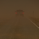
Overcast

86°F

30°C

Humidity 33%
Wind Speed S 6 mph
Barometer 30.18 in
Dewpoint 54°F (12°C)
Visibility 10.00 mi
Heat Index84°F (29°C)
Last update 16 Aug 2:40 pm CDT
Extended Forecast for

5 Miles NW Socorro TX

  • This Afternoon

    This Afternoon: A 20 percent chance of showers and thunderstorms after 3pm.  Partly sunny, with a high near 90. South southwest wind around 5 mph.

    High: 90 °F

    Slight Chance
    T-storms

  • Tonight

    Tonight: A 20 percent chance of showers and thunderstorms before 1am.  Mostly cloudy, with a low around 73. South wind 3 to 6 mph.

    Low: 73 °F

    Slight Chance
    T-storms

  • Sunday

    Sunday: A 40 percent chance of showers and thunderstorms, mainly after 3pm.  Mostly sunny, with a high near 93. South wind 3 to 5 mph.

    High: 93 °F

    Mostly Sunny
    then Chance
    T-storms

  • Sunday Night

    Sunday Night: A 40 percent chance of showers and thunderstorms.  Mostly cloudy, with a low around 74. South wind around 5 mph becoming calm  after midnight.

    Low: 74 °F

    Chance
    T-storms

  • Monday

    Monday: A 30 percent chance of showers and thunderstorms after noon.  Mostly sunny, with a high near 95. Calm wind becoming southeast around 6 mph in the afternoon.

    High: 95 °F

    Mostly Sunny
    then Chance
    T-storms

  • Monday Night

    Monday Night: A 30 percent chance of showers and thunderstorms, mainly before midnight.  Mostly cloudy, with a low around 75. East southeast wind around 6 mph becoming calm  in the evening.

    Low: 75 °F

    Chance
    T-storms

  • Tuesday

    Tuesday: A 30 percent chance of showers and thunderstorms after noon.  Mostly sunny, with a high near 95. Calm wind becoming east around 6 mph in the afternoon.

    High: 95 °F

    Sunny then
    Chance
    T-storms

  • Tuesday Night

    Tuesday Night: A 20 percent chance of showers and thunderstorms before midnight.  Partly cloudy, with a low around 73. East wind 3 to 6 mph.

    Low: 73 °F

    Slight Chance
    T-storms then
    Partly Cloudy

  • Wednesday

    Wednesday: A 20 percent chance of showers and thunderstorms after noon.  Sunny, with a high near 95. East wind 3 to 8 mph.

    High: 95 °F

    Sunny then
    Slight Chance
    T-storms

Detailed Forecast

This Afternoon
A 20 percent chance of showers and thunderstorms after 3pm. Partly sunny, with a high near 90. South southwest wind around 5 mph.
Tonight
A 20 percent chance of showers and thunderstorms before 1am. Mostly cloudy, with a low around 73. South wind 3 to 6 mph.
Sunday
A 40 percent chance of showers and thunderstorms, mainly after 3pm. Mostly sunny, with a high near 93. South wind 3 to 5 mph.
Sunday Night
A 40 percent chance of showers and thunderstorms. Mostly cloudy, with a low around 74. South wind around 5 mph becoming calm after midnight.
Monday
A 30 percent chance of showers and thunderstorms after noon. Mostly sunny, with a high near 95. Calm wind becoming southeast around 6 mph in the afternoon.
Monday Night
A 30 percent chance of showers and thunderstorms, mainly before midnight. Mostly cloudy, with a low around 75. East southeast wind around 6 mph becoming calm in the evening.
Tuesday
A 30 percent chance of showers and thunderstorms after noon. Mostly sunny, with a high near 95. Calm wind becoming east around 6 mph in the afternoon.
Tuesday Night
A 20 percent chance of showers and thunderstorms before midnight. Partly cloudy, with a low around 73. East wind 3 to 6 mph.
Wednesday
A 20 percent chance of showers and thunderstorms after noon. Sunny, with a high near 95. East wind 3 to 8 mph.
Wednesday Night
A 20 percent chance of showers and thunderstorms before midnight. Mostly clear, with a low around 73.
Thursday
Sunny, with a high near 95.
Thursday Night
Mostly clear, with a low around 73.
Friday
Sunny, with a high near 95.
Basemap Options
Click map to change the forecast location
Loading map...

ABOUT THIS FORECAST

 
Point Forecast:
5 Miles NW Socorro TX
 31.71°N 106.32°W (Elev. 3701 ft)
12:15 pm MDT Aug 16, 2025
2pm MDT Aug 16, 2025-6pm MDT Aug 22, 2025
 
Get as KML Get as XML

Additional Resources

Radar & Satellite Image

Link to Local Radar Data Link to Satellite Data

Hourly Weather Forecast

National Digital Forecast Database