


News Headlines

Current conditions at
Fort Benning (KLSF)
Lat: 32.33°NLon: 84.83°WElev: 233ft.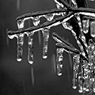
Light Freezing Rain Freezing Fog
28°F
-2°C
| Humidity | 95% |
| Wind Speed | W 5 mph |
| Barometer | 30.20 in (1023.4 mb) |
| Dewpoint | 27°F (-3°C) |
| Visibility | 0.25 mi |
| Wind Chill | 22°F (-6°C) |
| Last update | 9 Dec 6:55 am EST |
Extended Forecast for
4 Miles WSW Mauk GA
Today

High: 51 °F
Decreasing
CloudsTonight

Low: 32 °F
Mostly Clear
Wednesday

High: 60 °F
Sunny
Wednesday Night
Low: 36 °F
Mostly Clear
Thursday
High: 55 °F
Sunny
Thursday Night

Low: 34 °F
Clear
Friday

High: 61 °F
Sunny
Friday Night
Low: 42 °F
Mostly Clear
Saturday

High: 65 °F
Mostly Sunny
Detailed Forecast
Today
Mostly cloudy, then gradually becoming sunny, with a high near 51. Northeast wind around 5 mph becoming southwest in the afternoon.
Tonight
Mostly clear, with a low around 32. Calm wind becoming southwest around 5 mph after midnight.
Wednesday
Sunny, with a high near 60. Southwest wind 5 to 15 mph, with gusts as high as 25 mph.
Wednesday Night
Mostly clear, with a low around 36. Northwest wind 5 to 10 mph, with gusts as high as 20 mph.
Thursday
Sunny, with a high near 55. Northwest wind 5 to 10 mph, with gusts as high as 15 mph.
Thursday Night
Clear, with a low around 34.
Friday
Sunny, with a high near 61.
Friday Night
Mostly clear, with a low around 42.
Saturday
Mostly sunny, with a high near 65.
Saturday Night
Mostly clear, with a low around 45.
Sunday
Mostly sunny, with a high near 63.
Sunday Night
Mostly clear, with a low around 33.
Monday
Mostly sunny, with a high near 52.
Additional Forecasts and Information
Basemap Options
Click map to change the forecast location
Loading map...
ABOUT THIS FORECAST
Point Forecast:
4 Miles WSW Mauk GA
32.49°N 84.44°W (Elev. 699 ft)
32.49°N 84.44°W (Elev. 699 ft)
1:16 am EST Dec 9, 2025
7am EST Dec 9, 2025-6pm EST Dec 15, 2025
Additional Resources
Radar & Satellite Image


Hourly Weather Forecast


