Coastal Flood Watches Begin Early on Saturday - Updated Briefing

Strong northeasterly winds will develop Saturday and will continue into next week. These strong winds will combine with high astronomical tides associated with the upcoming full moon to create significant coastal and tidal flooding. Coastal Flood Watches have been issued along the southeast GA and northeast FL Atlantic coast and also within the St. Johns River basin beginning early on Saturday. Read More >

Current conditions at

Northeast Florida Regional Airport (KSGJ)

Lat: 29.96°NLon: 81.34°WElev: 3ft.

Partly Cloudy

76°F

24°C

Humidity 54%
Wind Speed N 17 G 22 mph
Barometer 30.14 in (1020.5 mb)
Dewpoint 58°F (14°C)
Visibility 10.00 mi
Heat Index78°F (26°C)
Last update 23 Oct 12:56 pm EDT
Extended Forecast for

Saint Augustine FL

Coastal Flood Watch October 24, 02:00am until October 26, 08:00pm
Coastal Flood Advisory October 23, 01:51pm until October 24, 02:00am
Click here for hazard details and duration
Coastal Flood Watch
Coastal Flood Advisory
  •  
    Coastal Flood Advisory October 23, 01:51pm until October 24, 02:00am

    NOW until 2:00am Sat

    Coastal Flood Advisory

  • This Afternoon

    High: 74 °F

    Sunny and
    Breezy

  • Tonight

    Tonight: A 20 percent chance of showers after 3am.  Mostly clear, with a low around 66. Windy, with a northeast wind 17 to 20 mph, with gusts as high as 25 mph.

    Low: 66 °F

    Mostly Clear
    and Windy
    then Slight
    Chance
    Showers and
    Breezy

  • Saturday

    Saturday: Showers, with thunderstorms also possible after 2pm.  High near 74. Very windy, with a north wind 21 to 28 mph, with gusts as high as 36 mph.  Chance of precipitation is 90%. New rainfall amounts between a quarter and half of an inch possible.

    High: 74 °F

    Showers
    Likely and
    Windy then
    Showers and
    Very Windy

  • Saturday Night

    Saturday Night: Showers and thunderstorms before midnight, then showers likely and possibly a thunderstorm between midnight and 2am, then a chance of showers after 2am.  Low around 70. Very windy, with a northeast wind around 26 mph, with gusts as high as 37 mph.  Chance of precipitation is 80%.

    Low: 70 °F

    Showers and
    Very Windy

  • Sunday

    Sunday: Showers likely, mainly after 2pm.  Mostly cloudy, with a high near 75. Very windy, with a northeast wind around 25 mph, with gusts as high as 34 mph.  Chance of precipitation is 70%.

    High: 75 °F

    Showers
    Likely and
    Very Windy

  • Sunday Night

    Sunday Night: Showers likely, mainly before 2am.  Mostly cloudy, with a low around 70. Very windy.  Chance of precipitation is 60%.

    Low: 70 °F

    Showers
    Likely and
    Very Windy

  • Monday

    Monday: A 50 percent chance of showers.  Partly sunny, with a high near 75. Very windy.

    High: 75 °F

    Chance
    Showers and
    Very Windy

  • Monday Night

    Monday Night: A 20 percent chance of showers before 2am.  Partly cloudy, with a low around 68. Windy.

    Low: 68 °F

    Slight Chance
    Showers and
    Windy

Detailed Forecast

This Afternoon
Sunny, with a high near 74. Breezy, with a north wind around 18 mph, with gusts as high as 23 mph.
Tonight
A 20 percent chance of showers after 3am. Mostly clear, with a low around 66. Windy, with a northeast wind 17 to 20 mph, with gusts as high as 25 mph.
Saturday
Showers, with thunderstorms also possible after 2pm. High near 74. Very windy, with a north wind 21 to 28 mph, with gusts as high as 36 mph. Chance of precipitation is 90%. New rainfall amounts between a quarter and half of an inch possible.
Saturday Night
Showers and thunderstorms before midnight, then showers likely and possibly a thunderstorm between midnight and 2am, then a chance of showers after 2am. Low around 70. Very windy, with a northeast wind around 26 mph, with gusts as high as 37 mph. Chance of precipitation is 80%.
Sunday
Showers likely, mainly after 2pm. Mostly cloudy, with a high near 75. Very windy, with a northeast wind around 25 mph, with gusts as high as 34 mph. Chance of precipitation is 70%.
Sunday Night
Showers likely, mainly before 2am. Mostly cloudy, with a low around 70. Very windy. Chance of precipitation is 60%.
Monday
A 50 percent chance of showers. Partly sunny, with a high near 75. Very windy.
Monday Night
A 20 percent chance of showers before 2am. Partly cloudy, with a low around 68. Windy.
Tuesday
A 20 percent chance of showers after 2pm. Sunny, with a high near 74. Windy.
Tuesday Night
A 10 percent chance of showers before 8pm. Partly cloudy, with a low around 68. Breezy.
Wednesday
A 20 percent chance of showers. Mostly sunny, with a high near 75. Windy.
Wednesday Night
A 20 percent chance of showers. Partly cloudy, with a low around 67. Breezy.
Thursday
A 30 percent chance of showers. Mostly sunny, with a high near 74. Breezy.
Basemap Options
Click map to change the forecast location
Loading map...

ABOUT THIS FORECAST

 
Point Forecast:
Saint Augustine FL
 29.9°N 81.3°W
1:36 pm EDT Oct 23, 2026
1pm EDT Oct 23, 2026-6pm EDT Oct 29, 2026
 
Get as KML Get as XML

Additional Resources

Radar & Satellite Image
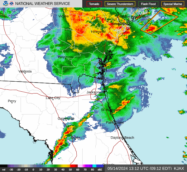
Link to Local Radar Data Link to Satellite Data

Hourly Weather Forecast

National Digital Forecast Database