


Dangerous Heat in the Central and Eastern U.S.; Severe Thunderstorms in the Central U.S. and Northeast; Critical Fire Weather in the Four Corners
Dangerous, record-breaking heat will intensify across most of the central and eastern U.S this week. Heat indices will likely exceed 100 degrees. Severe thunderstorms are forecast across parts of the Upper Midwest into the Great Lakes, the Northeast, and the central High Plains. Critical fire weather conditions will continue across portions of the Four Corners and Great Basin. Read More >
Hazardous Weather Conditions

Current conditions at
Miami University Airport (KOXD)
Lat: 39.5° N Lon: 84.78° W Elev: 1041 ft.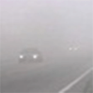
Fog/Mist
76°F
24°C
| Humidity | 100% |
| Wind Speed | SW 5 mph |
| Barometer | 30.12 in |
| Dewpoint | 76°F (24°C) |
| Visibility | 5.00 mi |
| Heat Index | 75°F (24°C) |
| Last update | 1 Jul 7:55 am EDT |
Detailed forecast for
Franklin County
Today
Sunny, hot with highs in the mid 90s. Light and variable winds, becoming southwest around 5 mph this late morning and afternoon. Heat index values up to 105.
Tonight
Clear, muggy. Lows in the mid 70s. Southwest winds around 5 mph.
Thursday
Mostly sunny. Hot with highs in the mid 90s. Southwest winds around 5 mph. Heat index values up to 107.
Thursday Night
Mostly clear. Muggy. Lows in the mid 70s. Southwest winds around 5 mph in the evening, becoming light and variable.
Friday
Mostly sunny in the morning, then partly cloudy with a slight chance of showers and thunderstorms in the afternoon. Hot with highs in the mid 90s. Light and variable winds, becoming southwest around 5 mph in the afternoon. Chance of rain 20 percent. Heat index values up to 104.
Friday Night
Partly cloudy with a chance of showers and thunderstorms. Lows in the lower 70s. Chance of rain 30 percent.
Independence Day
Partly cloudy with a chance of showers and thunderstorms. Highs around 90. Chance of rain 50 percent.
Saturday Night
Partly cloudy with a chance of showers and thunderstorms. Lows in the lower 70s. Chance of rain 50 percent.
Sunday
Partly cloudy. A chance of showers and thunderstorms in the morning, then showers likely with a chance of thunderstorms in the afternoon. Highs around 90. Chance of rain 60 percent.
Sunday Night
Partly cloudy. Showers likely with a chance of thunderstorms in the evening, then a chance of showers and thunderstorms after midnight. Lows in the lower 70s. Chance of rain 60 percent.
Monday
Partly cloudy. A chance of showers and thunderstorms in the afternoon. Highs in the upper 80s. Chance of rain 40 percent.
Monday Night
Partly cloudy. A chance of showers and thunderstorms in the evening. Lows in the upper 60s. Chance of rain 40 percent.
Tuesday
Partly cloudy. A chance of showers and thunderstorms in the afternoon. Highs in the upper 80s. Chance of rain 40 percent.
Basemap Options
Click map to change the forecast location
Loading map...
Additional Resources
Radar & Satellite Image


Hourly Weather Forecast


