


News Headlines
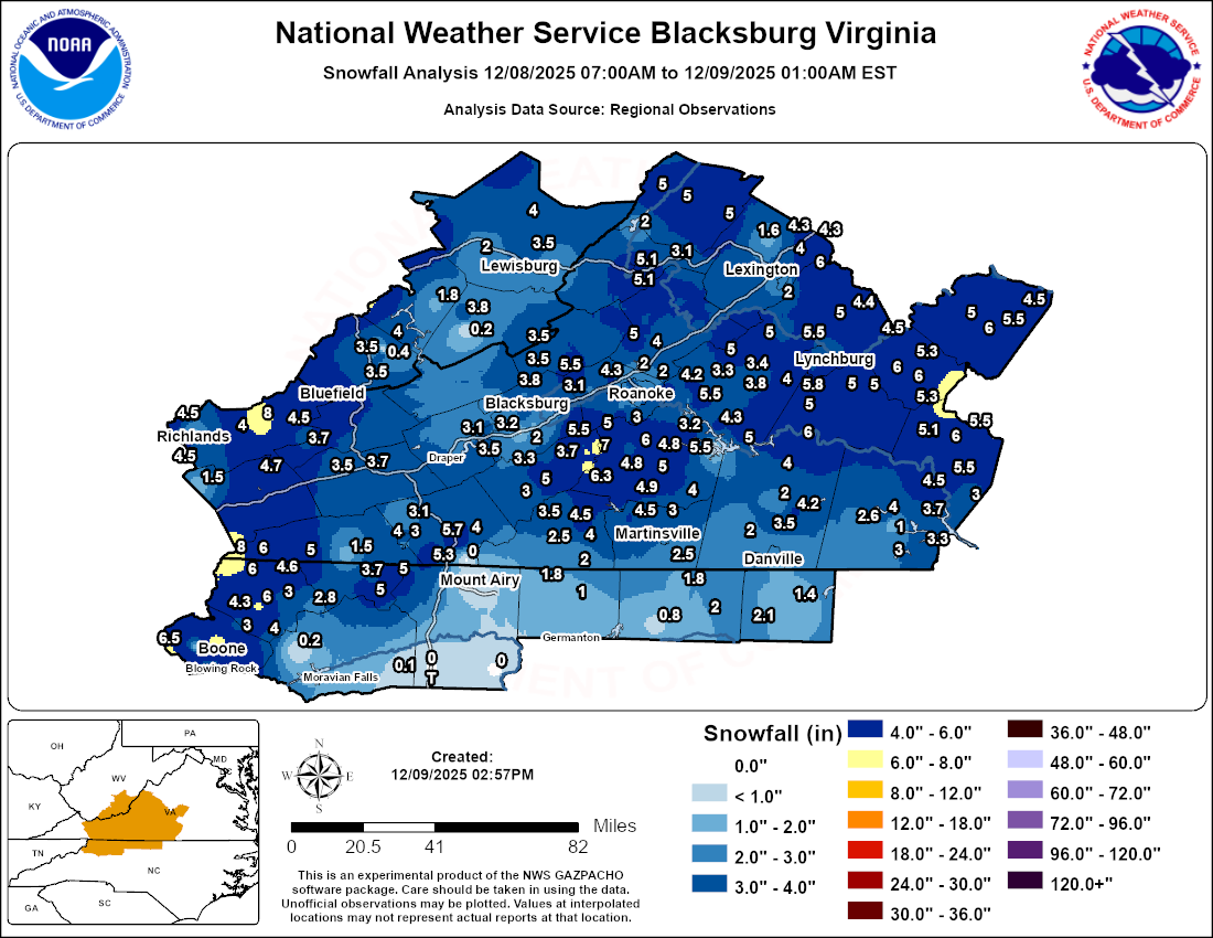
- Snowfall Analysis From the December 8th, 2025 Storm
- Office Newsletter: Latest Edition
- This week is Winter Weather Preparedness Week for North Carolina! Don't wait until the last minute before a storm to prepare!
- This is Winter Weather Preparedness Week for Virginia. Learn more about how you can be prepared for wintery conditions.

Hazardous Weather Conditions
Current conditions at
Watauga County Hospital Heliport (KTNB)
Lat: 36.2°NLon: 81.65°WElev: 3146ft.
Mostly Cloudy
37°F
3°C
| Humidity | 85% |
| Wind Speed | W 10 G 17 mph |
| Barometer | 29.64 in |
| Dewpoint | 33°F (1°C) |
| Visibility | 10.00 mi |
| Wind Chill | 30°F (-1°C) |
| Last update | 10 Dec 6:55 pm EST |
Extended Forecast for
Zionville NC
Winter Weather Advisory December 10, 07:05pm until December 11, 10:00am
NOW until 10:00am Thu

Winter Weather Advisory
Tonight

Low: 22 °F
Snow Likely
and BreezyThursday
High: 27 °F
Scattered
Snow Showers
then Isolated
Snow ShowersThursday Night
Low: 20 °F
Partly Cloudy
then Chance
SnowFriday
High: 39 °F
Chance Snow
then Chance
Rain/SnowFriday Night

Low: 28 °F
Mostly Cloudy
Saturday

High: 39 °F
Mostly Sunny
Saturday Night

Low: 22 °F
Partly Cloudy
Sunday

High: 27 °F
Decreasing
Clouds
Detailed Forecast
Tonight
Snow likely, mainly after midnight. Cloudy, with a low around 22. Breezy, with a northwest wind around 22 mph, with gusts as high as 40 mph. Chance of precipitation is 70%. Total nighttime snow accumulation of 1 to 3 inches possible.
Thursday
Scattered snow showers before 1pm, then scattered flurries between 1pm and 3pm. Mostly cloudy, with a high near 27. Northwest wind 11 to 18 mph, with gusts as high as 36 mph. Chance of precipitation is 50%. New snow accumulation of less than a half inch possible.
Thursday Night
A chance of snow, mainly after 4am. Mostly cloudy, with a low around 20. West wind 6 to 8 mph. Chance of precipitation is 30%.
Friday
A chance of rain and snow before 1pm, then a slight chance of rain between 1pm and 4pm, then a slight chance of rain and snow after 4pm. Partly sunny, with a high near 39. West wind 6 to 8 mph. Chance of precipitation is 30%. New precipitation amounts of less than a tenth of an inch possible.
Friday Night
Mostly cloudy, with a low around 28. West wind 8 to 13 mph, with gusts as high as 25 mph.
Saturday
Mostly sunny, with a high near 39.
Saturday Night
Partly cloudy, with a low around 22.
Sunday
Mostly cloudy, then gradually becoming sunny, with a high near 27.
Sunday Night
Mostly clear, with a low around 4.
Monday
Sunny, with a high near 32.
Monday Night
Mostly clear, with a low around 19.
Tuesday
Mostly sunny, with a high near 40.
Tuesday Night
Partly cloudy, with a low around 27.
Wednesday
Partly sunny, with a high near 44.
Additional Forecasts and Information
Basemap Options
Click map to change the forecast location
Loading map...
ABOUT THIS FORECAST
Point Forecast:
Zionville NC
36.34°N 81.73°W (Elev. 3596 ft)
36.34°N 81.73°W (Elev. 3596 ft)
7:00 pm EST Dec 10, 2025
7pm EST Dec 10, 2025-6pm EST Dec 17, 2025
Additional Resources
Radar & Satellite Image


Hourly Weather Forecast


