


News Headlines
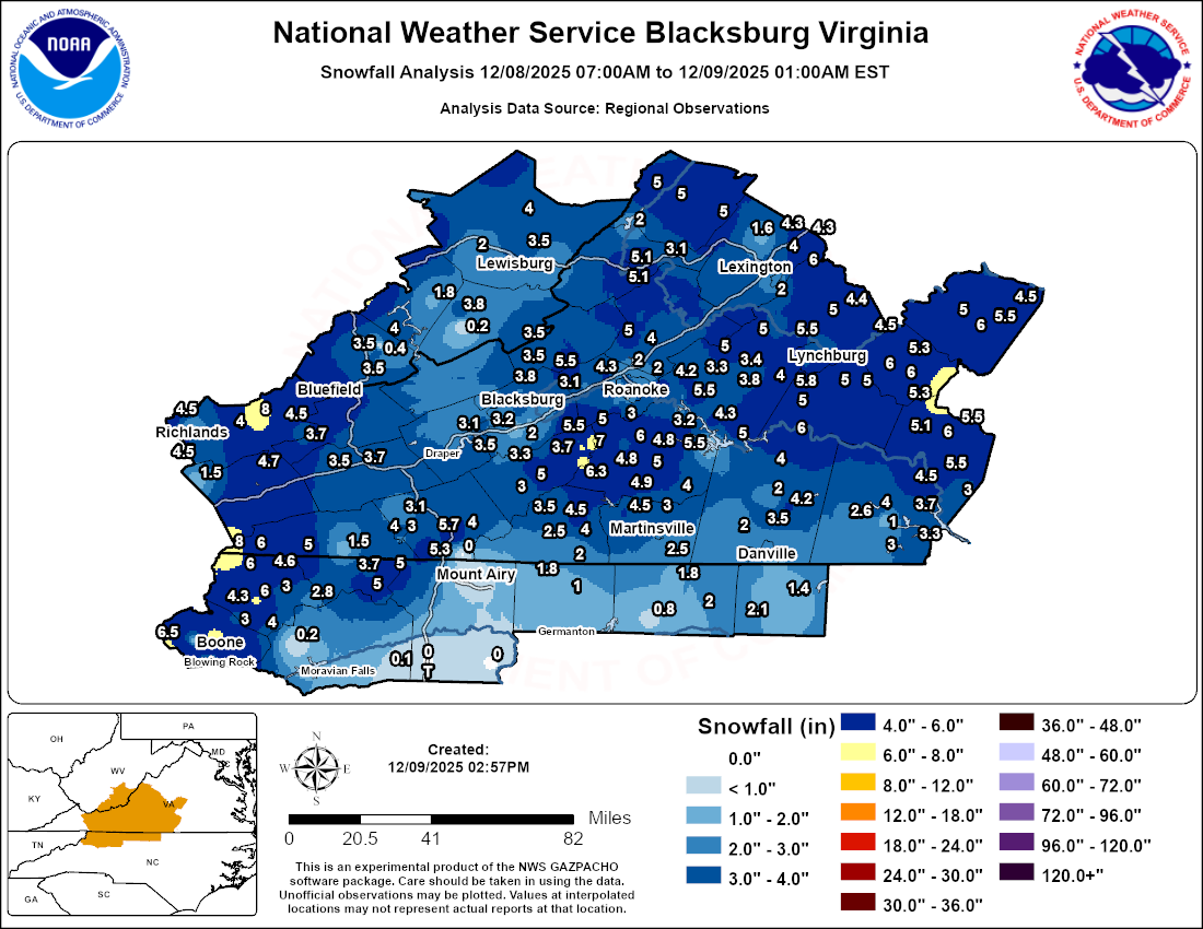
- Snowfall Analysis From the December 8th, 2025 Storm
- Office Newsletter: Latest Edition
- This week is Winter Weather Preparedness Week for North Carolina! Don't wait until the last minute before a storm to prepare!
- This is Winter Weather Preparedness Week for Virginia. Learn more about how you can be prepared for wintery conditions.

Hazardous Weather Conditions
Current conditions at
Marion / Wytheville (KMKJ)
Lat: 36.9°NLon: 81.35°WElev: 2559ft.
Light Rain
36°F
2°C
| Humidity | 89% |
| Wind Speed | W 9 G 18 mph |
| Barometer | 29.62 in |
| Dewpoint | 33°F (1°C) |
| Visibility | 7.00 mi |
| Wind Chill | 29°F (-2°C) |
| Last update | 10 Dec 4:35 pm EST |
Extended Forecast for
Wytheville VA
This Afternoon

High: 45 °F
Rain Likely
Tonight
Low: 25 °F
Rain/Snow
Likely then
Slight Chance
SnowThursday
High: 31 °F
Isolated Snow
Showers then
Partly SunnyThursday Night
Low: 22 °F
Mostly Cloudy
then Chance
SnowFriday
High: 39 °F
Snow Likely
then Chance
Rain/SnowFriday Night
Low: 26 °F
Slight Chance
Rain/Snow
then Mostly
CloudySaturday

High: 40 °F
Mostly Sunny
Saturday Night
Low: 20 °F
Mostly Cloudy
then Chance
SnowSunday

High: 24 °F
Partly Sunny
Detailed Forecast
This Afternoon
Rain likely, mainly before 5pm. Cloudy, with a high near 45. West wind around 14 mph, with gusts as high as 25 mph. Chance of precipitation is 70%. New precipitation amounts of less than a tenth of an inch possible.
Tonight
Rain likely before 8pm, then a chance of rain and snow between 8pm and 10pm, then a slight chance of snow after 10pm. Mostly cloudy, with a low around 25. West wind 11 to 14 mph, with gusts as high as 28 mph. Chance of precipitation is 70%. New snow accumulation of less than a half inch possible.
Thursday
Isolated snow showers before 8am, then scattered flurries between 8am and 10am. Partly sunny, with a high near 31. West wind 10 to 14 mph, with gusts as high as 25 mph. Chance of precipitation is 20%.
Thursday Night
A chance of snow, mainly after 3am. Mostly cloudy, with a low around 22. West wind around 5 mph becoming calm in the evening. Chance of precipitation is 40%.
Friday
Snow likely before noon, then a chance of rain and snow between noon and 2pm, then a chance of rain after 2pm. Mostly cloudy, with a high near 39. Calm wind becoming southwest 5 to 7 mph in the morning. Chance of precipitation is 60%. New snow accumulation of less than a half inch possible.
Friday Night
A slight chance of rain and snow before 10pm. Mostly cloudy, with a low around 26. Chance of precipitation is 20%.
Saturday
Mostly sunny, with a high near 40.
Saturday Night
A chance of snow after 1am. Mostly cloudy, with a low around 20. Chance of precipitation is 30%.
Sunday
Partly sunny, with a high near 24.
Sunday Night
Mostly clear, with a low around 3.
Monday
Sunny, with a high near 32.
Monday Night
Mostly clear, with a low around 18.
Tuesday
Mostly sunny, with a high near 42.
Additional Forecasts and Information
Basemap Options
Click map to change the forecast location
Loading map...
ABOUT THIS FORECAST
Point Forecast:
Wytheville VA
36.96°N 81.09°W (Elev. 2402 ft)
36.96°N 81.09°W (Elev. 2402 ft)
4:00 pm EST Dec 10, 2025
4pm EST Dec 10, 2025-6pm EST Dec 16, 2025
Additional Resources
Radar & Satellite Image


Hourly Weather Forecast


