

Showers and Thunderstorms Bring Flooding Concerns into the Weekend

Rounds of heavy showers and storms are expected through Saturday night. Locally heavy rain could result in flash flooding today and Saturday. In addition, isolated strong storms are possible in portions of the higher mountainous terrain this afternoon and evening, with the threat being damaging wind gusts. Please keep updated on the latest forecast and have multiple ways to receive warnings. Read More >

Hazardous Weather Conditions

Current conditions at

Charleston, Yeager Airport (KCRW)

Lat: 38.38°NLon: 81.59°WElev: 981ft.

Mostly Cloudy

80°F

27°C

Humidity 74%
Wind Speed SW 8 mph
Barometer 29.93 in (1012.8 mb)
Dewpoint 71°F (22°C)
Visibility 10.00 mi
Heat Index83°F (28°C)
Last update 10 Jul 6:54 pm EDT
Extended Forecast for

Chesapeake WV

Flood Watch July 10, 07:34pm until July 12, 08:00am
Click here for hazard details and duration
Flood Watch
  •  
    Flood Watch July 10, 07:34pm until July 12, 08:00am

    NOW until 8:00am Sun

    Flood Watch

  • Tonight

    Low: 68 °F

    Showers
    Likely then
    Slight Chance
    T-storms

  • Saturday

    Saturday: Showers and thunderstorms likely, then showers and possibly a thunderstorm after 4pm.  High near 80. Light southwest wind.  Chance of precipitation is 80%. New rainfall amounts between a tenth and quarter of an inch, except higher amounts possible in thunderstorms.

    High: 80 °F

    Chance
    T-storms then
    Showers

  • Saturday Night

    Saturday Night: Showers and thunderstorms likely before midnight, then a slight chance of showers between midnight and 1am.  Mostly cloudy, with a low around 66. Calm wind.  Chance of precipitation is 60%. New precipitation amounts between a quarter and half of an inch possible.

    Low: 66 °F

    Showers
    Likely then
    Slight Chance
    Showers

  • Sunday

    Sunday: A chance of showers before 11am, then a chance of showers and thunderstorms between 11am and 2pm, then showers likely and possibly a thunderstorm after 2pm.  Mostly cloudy, with a high near 82. Calm wind.  Chance of precipitation is 60%. New rainfall amounts of less than a tenth of an inch, except higher amounts possible in thunderstorms.

    High: 82 °F

    Chance
    Showers then
    Showers
    Likely

  • Sunday Night

    Sunday Night: Showers and thunderstorms likely before 11pm, then a chance of showers.  Mostly cloudy, with a low around 66. Calm wind.  Chance of precipitation is 60%. New precipitation amounts of less than a tenth of an inch, except higher amounts possible in thunderstorms.

    Low: 66 °F

    Showers
    Likely then
    Chance
    Showers

  • Monday

    Monday: A slight chance of showers, with thunderstorms also possible after 2pm.  Partly sunny, with a high near 82. Chance of precipitation is 20%.

    High: 82 °F

    Slight Chance
    Showers then
    Slight Chance
    T-storms

  • Monday Night

    Monday Night: Partly cloudy, with a low around 65.

    Low: 65 °F

    Partly Cloudy

  • Tuesday

    Tuesday: Sunny, with a high near 87.

    High: 87 °F

    Sunny

Detailed Forecast

Tonight
Showers and thunderstorms likely before 4am, then a slight chance of showers between 4am and 5am, then a slight chance of showers and thunderstorms after 5am. Mostly cloudy, with a low around 68. Southwest wind around 5 mph becoming calm in the evening. Chance of precipitation is 60%. New rainfall amounts of less than a tenth of an inch, except higher amounts possible in thunderstorms.
Saturday
Showers and thunderstorms likely, then showers and possibly a thunderstorm after 4pm. High near 80. Light southwest wind. Chance of precipitation is 80%. New rainfall amounts between a tenth and quarter of an inch, except higher amounts possible in thunderstorms.
Saturday Night
Showers and thunderstorms likely before midnight, then a slight chance of showers between midnight and 1am. Mostly cloudy, with a low around 66. Calm wind. Chance of precipitation is 60%. New precipitation amounts between a quarter and half of an inch possible.
Sunday
A chance of showers before 11am, then a chance of showers and thunderstorms between 11am and 2pm, then showers likely and possibly a thunderstorm after 2pm. Mostly cloudy, with a high near 82. Calm wind. Chance of precipitation is 60%. New rainfall amounts of less than a tenth of an inch, except higher amounts possible in thunderstorms.
Sunday Night
Showers and thunderstorms likely before 11pm, then a chance of showers. Mostly cloudy, with a low around 66. Calm wind. Chance of precipitation is 60%. New precipitation amounts of less than a tenth of an inch, except higher amounts possible in thunderstorms.
Monday
A slight chance of showers, with thunderstorms also possible after 2pm. Partly sunny, with a high near 82. Chance of precipitation is 20%.
Monday Night
Partly cloudy, with a low around 65.
Tuesday
Sunny, with a high near 87.
Tuesday Night
Mostly clear, with a low around 68.
Wednesday
Sunny, with a high near 89.
Wednesday Night
Mostly clear, with a low around 70.
Thursday
Mostly sunny, with a high near 88.
Thursday Night
Partly cloudy, with a low around 68.
Friday
A 40 percent chance of showers and thunderstorms. Mostly sunny, with a high near 87.
Basemap Options
Click map to change the forecast location
Loading map...

ABOUT THIS FORECAST

 
Point Forecast:
Chesapeake WV
 38.21°N 81.55°W (Elev. 1148 ft)
6:35 pm EDT Jul 10, 2026
7pm EDT Jul 10, 2026-6pm EDT Jul 17, 2026
 
Get as KML Get as XML

Additional Resources

Radar & Satellite Image
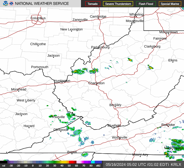
Link to Local Radar Data Link to Satellite Data

Hourly Weather Forecast

National Digital Forecast Database


