


Hazardous Weather Conditions

Current conditions at
Sarasota / Bradenton, Sarasota-Bradenton International Airport (KSRQ)
Lat: 27.4° N Lon: 82.56° W Elev: 30 ft.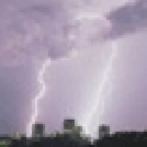
Thunderstorm in Vicinity Light Rain
77°F
25°C
| Humidity | 90% |
| Wind Speed | S 3 mph |
| Barometer | 29.96 in (1014.4 mb) |
| Dewpoint | 74°F (23°C) |
| Visibility | 8.00 mi |
| Heat Index | 78°F (26°C) |
| Last update | 19 Jul 4:53 am EDT |
Detailed forecast for
Coastal Manatee
Today
Numerous showers and scattered thunderstorms. Highs in the upper 80s. South winds 15 to 20 mph. Chance of rain 70 percent.
Tonight
Mostly cloudy with scattered showers and thunderstorms. Humid with lows in the upper 70s. South winds 15 to 20 mph. Chance of rain 50 percent.
Monday
Numerous showers and scattered thunderstorms. Breezy with highs around 90. South winds 15 to 25 mph. Chance of rain 70 percent. Heat index values up to 105.
Monday Night
Mostly cloudy in the evening, then becoming partly cloudy. Scattered thunderstorms. Numerous showers, mainly in the evening. Humid with lows around 80. South winds 15 to 20 mph with gusts up to 30 mph. Chance of rain 60 percent.
Tuesday
Mostly sunny with scattered showers and thunderstorms. Humid with highs in the lower 90s. South winds 15 to 20 mph with gusts up to 30 mph. Chance of rain 40 percent. Heat index values up to 106.
Tuesday Night Through Thursday Night
Partly cloudy with isolated showers and thunderstorms. Lows in the upper 70s. Highs in the lower 90s. Chance of rain 20 percent.
Friday
Sunny. Isolated showers and thunderstorms in the afternoon. Highs in the lower 90s. Chance of rain 20 percent. Heat index values up to 105.
Friday Night
Partly cloudy. Isolated showers and thunderstorms in the evening. Lows in the upper 70s. Chance of rain 20 percent.
Saturday
Sunny. Isolated showers and thunderstorms in the afternoon. Highs in the lower 90s. Chance of rain 20 percent. Heat index values up to 105.
Additional Forecasts and Information
Basemap Options
Click map to change the forecast location
Loading map...
Additional Resources
Radar & Satellite Image


Hourly Weather Forecast


