


Severe Thunderstorm and Flash Flooding Potential Returns Tuesday Afternoon and Evening
Thunderstorms Tuesday afternoon and evening could produce damaging winds and hail, particularly with a line that moves southeast ahead of an advancing cold front. A tornado or two, as well as Localized flash flooding, are also possible. There is a slight to enhanced Risk for Severe Storms, and a Slight Risk for Flash Flooding. Please keep updated on the forecast and have ways to receive warnings. Read More >

Current conditions at
Logan County Airport (K6L4)
Lat: 37.86° N Lon: 81.92° W Elev: 1667 ft.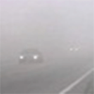
Fog
66°F
19°C
| Humidity | 100% |
| Wind Speed | Calm |
| Barometer | 30.01 in |
| Dewpoint | 66°F (19°C) |
| Visibility | 0.15 mi |
| Last update | 20 Jul 7:35 am EDT |
Detailed forecast for
Boone County
Today
Areas of dense fog and smoke this morning. Mostly sunny. Visibility one quarter mile or less at times this morning. Highs in the mid 80s. Light and variable winds, becoming west around 5 mph this afternoon.
Tonight
Partly cloudy in the evening, then becoming mostly cloudy. A slight chance of showers and thunderstorms. Humid with lows around 70. Southwest winds around 5 mph. Chance of rain 20 percent.
Tuesday
Mostly cloudy with a chance of showers. A slight chance of thunderstorms in the morning, then a chance of thunderstorms in the afternoon. Humid with highs in the mid 80s. Southwest winds 5 to 10 mph with gusts up to 25 mph. Chance of rain 50 percent.
Tuesday Night
Showers with thunderstorms likely in the evening, then showers with a chance of thunderstorms after midnight. Humid with lows in the upper 60s. Southwest winds 5 to 10 mph with gusts up to 25 mph. Chance of rain near 100 percent.
Wednesday
Mostly cloudy in the morning, then becoming mostly sunny. A chance of showers with a slight chance of thunderstorms. Humid with highs in the upper 70s. Northwest winds around 5 mph. Chance of rain 50 percent.
Wednesday Night Through Thursday Night
Mostly clear. Lows in the upper 50s. Highs in the upper 70s.
Friday And Friday Night
Mostly cloudy. Highs around 80. Lows in the mid 60s.
Saturday And Saturday Night
Partly cloudy. Highs in the upper 70s. Lows in the mid 60s.
Sunday
Mostly sunny. Highs in the mid 80s.
Additional Forecasts and Information
Basemap Options
Click map to change the forecast location
Loading map...
Additional Resources
Radar & Satellite Image


Hourly Weather Forecast


