


Hazardous Weather Conditions
Current conditions at
Williamsport - Lycoming County Airport (KIPT)
Lat: 41.24°NLon: 76.92°WElev: 522ft.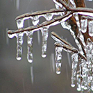
Light Freezing Rain Fog/Mist
31°F
-1°C
| Humidity | 89% |
| Wind Speed | E 9 mph |
| Barometer | 30.44 in (1031.4 mb) |
| Dewpoint | 28°F (-2°C) |
| Visibility | 2.50 mi |
| Wind Chill | 23°F (-5°C) |
| Last update | 3 Mar 9:54 am EST |
Extended Forecast for
Dushore PA
Winter Weather Advisory until March 3, 04:00pm
NOW until 4:00pm Tue

Winter Weather Advisory
Today

High: 36 °F
Wintry Mix
Tonight
Low: 35 °F
Rain then
Chance Rain
and Patchy
FogWednesday
High: 50 °F
Patchy Fog
then Partly
SunnyWednesday Night
Low: 37 °F
Chance Rain
then Rain
LikelyThursday

High: 50 °F
Rain Likely
Thursday Night

Low: 43 °F
Rain
Friday

High: 55 °F
Mostly Cloudy
Friday Night

Low: 42 °F
Mostly Cloudy
Detailed Forecast
Today
Snow, freezing rain, and sleet before noon, then rain, snow and freezing rain, possibly mixed with sleet between noon and 1pm, then rain after 1pm. High near 36. South wind around 10 mph. Chance of precipitation is 90%. Little or no ice accumulation expected. Total daytime snow and sleet accumulation of less than a half inch possible.
Tonight
Rain, mainly before 10pm. Patchy fog after 3am. Low around 35. South wind 5 to 8 mph becoming calm after midnight. Chance of precipitation is 90%. New precipitation amounts of less than a tenth of an inch possible.
Wednesday
Patchy fog before 10am. Otherwise, mostly cloudy, with a high near 50. Calm wind.
Wednesday Night
Rain likely, mainly after 1am. Mostly cloudy, with a low around 37. Light south wind. Chance of precipitation is 60%. New precipitation amounts of less than a tenth of an inch possible.
Thursday
Rain likely. Mostly cloudy, with a high near 50. South wind 3 to 5 mph. Chance of precipitation is 70%. New precipitation amounts between a quarter and half of an inch possible.
Thursday Night
Rain before 10pm, then rain and possibly a thunderstorm between 10pm and 4am, then rain after 4am. Low around 43. Chance of precipitation is 90%. New rainfall amounts between a quarter and half of an inch possible.
Friday
Mostly cloudy, with a high near 55.
Friday Night
Mostly cloudy, with a low around 42.
Saturday
A chance of rain after 1pm. Mostly cloudy, with a high near 61. Chance of precipitation is 50%.
Saturday Night
Rain likely, mainly before 1am. Mostly cloudy, with a low around 45. Chance of precipitation is 70%.
Sunday
Mostly sunny, with a high near 59.
Sunday Night
Partly cloudy, with a low around 45.
Monday
Mostly sunny, with a high near 62.
Additional Forecasts and Information
Basemap Options
Click map to change the forecast location
Loading map...
ABOUT THIS FORECAST
Point Forecast:
Dushore PA
41.53°N 76.41°W (Elev. 1768 ft)
41.53°N 76.41°W (Elev. 1768 ft)
9:36 am EST Mar 3, 2026
10am EST Mar 3, 2026-6pm EDT Mar 9, 2026
Additional Resources
Radar & Satellite Image


Hourly Weather Forecast


