


News Headlines
Hazardous Weather Conditions

Current conditions at
Cameron Memorial Airport (KEZZ)
Lat: 39.73° N Lon: 94.28° W Elev: 1040 ft.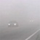
Fog/Mist
68°F
20°C
| Humidity | NA |
| Wind Speed | E 7 mph |
| Barometer | 29.97 in |
| Dewpoint | NA |
| Visibility | 1.25 mi |
| Last update | 27 Jun 9:15 am CDT |
Detailed forecast for
Clinton County
Rest Of Today
Mostly cloudy late this morning, then partly sunny with a slight chance of showers and thunderstorms this afternoon. Highs in the mid 80s. Southeast winds 10 to 15 mph with gusts up to 25 mph. Chance of rain 20 percent.
Tonight
Mostly cloudy with a slight chance of showers and thunderstorms in the evening, then partly cloudy after midnight. Lows in the lower 70s. Southeast winds 10 to 15 mph with gusts up to 25 mph. Chance of rain 20 percent.
Sunday
Sunny. Highs in the lower 90s. South winds 15 to 20 mph with gusts up to 35 mph. Heat index values up to 106 in the afternoon.
Sunday Night
Partly cloudy. Lows in the upper 70s. South winds 15 to 20 mph with gusts up to 35 mph. Heat index values up to 105 early in the evening.
Monday
Mostly sunny and breezy. Highs in the lower 90s. South winds 15 to 25 mph with gusts up to 35 mph. Heat index values up to 107 in the afternoon.
Monday Night
Partly cloudy. Lows in the upper 70s. Heat index values up to 105 early in the evening.
Tuesday Through Friday
Mostly clear. Highs in the lower 90s. Lows in the mid 70s. Heat index values up to 105.
Additional Forecasts and Information
Basemap Options
Click map to change the forecast location
Loading map...
Additional Resources
Radar & Satellite Image


Hourly Weather Forecast


